


FaunaMAppEr
Description of FaunaMAppEr
➣ Professional faunistic recording
➣ Birds, amphibians, reptiles, dragonflies...
➣ Capture projects created in 1 minute
➣ Maximized data entry efficiency
➣ Data transfer at the touch of a button
➣ Import and export of shapefiles
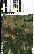
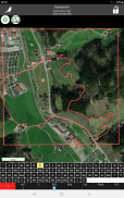
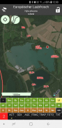
After defining the master data (year of collection, area name, client), the study area can be delimited using drawn polygons, lines, points or imported ESRI shapefiles. The following is a free download of offline aerial photos.
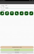
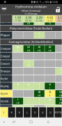
For each project, the species groups to be recorded can be selected and the inspections to be carried out can be created.
Current:
➣ Birds (method of territory mapping)
➣ Large birds and birds of prey (nest search/control, territory mapping, space use analysis)
➣ Amphibians
➣ Reptiles
➣ Dragonflies
➣ Bats
➣ Mammals (excluding bats)
➣ Beetles (FFH species)
➣ Grasshoppers
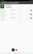
The recorded data (inspection data and observations) can be exported directly on site to a cloud or via email, which is also strongly recommended for data backup. This export can be done in CSV table format or as an ESRI shapefile. Tabular data can be transferred directly into reports without any significant reformatting, and observation data can be loaded directly into the GIS used.
The detailed description of species group modules, workflows, tips and tricks can be found in the current documentation:
➣ https://www.faunamapper.de/app/documentation
In order to be able to continuously develop the app, we see no other way than to offer the app as a subscription, so that every user makes a financial contribution to the further development.
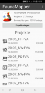
Three subscription models are currently offered, which differ in the number of projects and data sets that can be created:
Demo version:
Number of projects: 1, number of data sets: 250 - free of charge
Hobby version:
Number of projects: 3, number of data sets: 1000 - subject to a fee
Professional version (and sponsors ;-):
Number of projects: unlimited, number of data sets: unlimited - subject to a fee
FaunaMAppEr - Version 2.15.50
(25-05-2025)FaunaMAppEr - APK Information
APK Version: 2.15.50Package: de.faunamapper.mapperLatest Version of FaunaMAppEr
Other versions


 4.15
4.15


Apps in the same category

You may also like...


